Tabe: Difference between revisions
No edit summary |
No edit summary |
||
| Line 22: | Line 22: | ||
{{Settlements in Payalwa Sections | {{Settlements in Payalwa Sections | ||
|Introduction='''Tabe''' is the oldest [[Morusi]] city in [[Payalwa]]. | |Introduction='''Tabe''' is the oldest [[Morusi]] city in [[Payalwa]]. | ||
|History==== Founding and etymology === | |||
'''Tabe''' is the oldest human city in [[Payalwa]], founded in 201 of the modern era (ME). The city is named after [[Antero Tabe]], the leader of the early human expedition that reached and settled the realmnow known as Payalwa; he is regarded as the city's founder. The settlement was established at the mouth of the [[Apace River]], at the point where the river empties into [[Canea Bay]]. | |||
Canea Bay is a well-protected natural harbour, and the land immediately surrounding the city is dry and fertile, in contrast to the swampy terrain that characterizes much of Payalwa. The combination of a sheltered bay and arable land is likely to have informed the original choice of site for the settlement. | |||
=== Growth and heritage === | |||
As the earliest human foundation in Payalwa, Tabe accumulated a substantial historical and cultural heritage over the centuries following its establishment. Many of its surviving structures date from the year 400 (ME) onward, reflecting a long period of continuous occupation, and the city's inhabitants are noted for their pride in their history. | |||
Tabe developed as a port city and came to occupy a position on the principal road running along the southern coast of Payalwa between [[Harrowmere]] and [[Monleg]]. This location, together with its harbour, gave the city convenient access both to other parts of Payalwa and to realms beyond, supporting its growth into an established regional center. By the modern period its population had reached approximately 24,000. | |||
|Geography==== Location and setting === | |||
'''Tabe''' lies on the southern coast of '''Payalwa''', at the point where the '''Apace River''' discharges into '''Canea Bay'''. The city occupies the low ground at the river's mouth and '''spreads back along both banks onto the gently rising land behind the shore'''. Canea Bay is a well-protected inlet, '''sheltered from the open sea by a belt of low headlands and small offshore islands that break the force of wind and waves and account for the bay's calm, navigable waters'''. The bay opens southward onto '''the wider sea beyond''', giving the city its character as a port and its access to the rest of Payalwa and to more distant realms. | |||
Tabe stands on the coastal road that runs between '''Harrowmere''' and '''Monleg''', placing it on the principal overland route along Payalwa's southern seaboard. | |||
=== Terrain and hydrography === | |||
The land immediately around Tabe is dry and fertile, forming '''a band of arable coastal lowland''' that contrasts sharply with the terrain of the wider region. Most of Payalwa consists of '''low-lying, poorly drained country dominated by marshes, bogs, and mires''', so that the comparatively well-drained ground at Canea Bay represents '''a relatively favourable pocket of farmland and settlement amid an otherwise waterlogged landscape'''. The '''Apace River''' is the principal watercourse of the immediate area, '''draining the interior wetlands toward the coast''' and providing both fresh water and a route inland from the harbour. | |||
=== Climate === | |||
Tabe has '''a cool, humid climate transitional between temperate and boreal conditions, broadly comparable to that of the eastern Baltic and Fennoscandian coasts'''. Winters are '''long and cold, with sustained sub-freezing temperatures and reliable snow cover for several months of the year''', while summers are '''short and mild rather than hot'''. Precipitation is '''moderate and distributed across the year''', contributing to the prevalence of wetlands across the surrounding region. | |||
The presence of Canea Bay and the open sea exerts '''a moderating influence on the city's temperatures'''. Although the coastal waters are '''cold for much of the year''', they '''do not freeze solid; at most, thin or broken seasonal ice forms in the shelter of the bay during the coldest period, leaving the harbour usable, or readily navigable, for most of the year'''. This combination of a sheltered, largely ice-free harbour and a temperate-boreal hinterland is '''central to Tabe's viability as a year-round port'''. | |||
|Gallery={{Slideshow| | |Gallery={{Slideshow| | ||
Tabe Photograph.jpg :: Photograph of Tabe. | Tabe Photograph.jpg :: Photograph of Tabe. | ||
Revision as of 19:38, 14 June 2026
| Tabe | |||
|---|---|---|---|
| Image |  Watercolor of Trabe ca. 400-500 | ||
| Type | Historic City | ||
| Coat of Arms |  | ||
| Nickname(s) | The First City | ||
| Location | Falanga | ||
| Country | League of Payalwa | ||
| State | Trael | ||
| Region | Western Lowlands | ||
| Realm | Payalwa | ||
| Founded | 201 | ||
| Goverment |
| ||
| Population | 24k | ||
| Inhabitants | Morusi | ||
Introduction
Tabe is the oldest Morusi city in Payalwa.
History
Founding and etymology
Tabe is the oldest human city in Payalwa, founded in 201 of the modern era (ME). The city is named after Antero Tabe, the leader of the early human expedition that reached and settled the realmnow known as Payalwa; he is regarded as the city's founder. The settlement was established at the mouth of the Apace River, at the point where the river empties into Canea Bay.
Canea Bay is a well-protected natural harbour, and the land immediately surrounding the city is dry and fertile, in contrast to the swampy terrain that characterizes much of Payalwa. The combination of a sheltered bay and arable land is likely to have informed the original choice of site for the settlement.
Growth and heritage
As the earliest human foundation in Payalwa, Tabe accumulated a substantial historical and cultural heritage over the centuries following its establishment. Many of its surviving structures date from the year 400 (ME) onward, reflecting a long period of continuous occupation, and the city's inhabitants are noted for their pride in their history.
Tabe developed as a port city and came to occupy a position on the principal road running along the southern coast of Payalwa between Harrowmere and Monleg. This location, together with its harbour, gave the city convenient access both to other parts of Payalwa and to realms beyond, supporting its growth into an established regional center. By the modern period its population had reached approximately 24,000.
Geography
Location and setting
Tabe lies on the southern coast of Payalwa, at the point where the Apace River discharges into Canea Bay. The city occupies the low ground at the river's mouth and spreads back along both banks onto the gently rising land behind the shore. Canea Bay is a well-protected inlet, sheltered from the open sea by a belt of low headlands and small offshore islands that break the force of wind and waves and account for the bay's calm, navigable waters. The bay opens southward onto the wider sea beyond, giving the city its character as a port and its access to the rest of Payalwa and to more distant realms.
Tabe stands on the coastal road that runs between Harrowmere and Monleg, placing it on the principal overland route along Payalwa's southern seaboard.
Terrain and hydrography
The land immediately around Tabe is dry and fertile, forming a band of arable coastal lowland that contrasts sharply with the terrain of the wider region. Most of Payalwa consists of low-lying, poorly drained country dominated by marshes, bogs, and mires, so that the comparatively well-drained ground at Canea Bay represents a relatively favourable pocket of farmland and settlement amid an otherwise waterlogged landscape. The Apace River is the principal watercourse of the immediate area, draining the interior wetlands toward the coast and providing both fresh water and a route inland from the harbour.
Climate
Tabe has a cool, humid climate transitional between temperate and boreal conditions, broadly comparable to that of the eastern Baltic and Fennoscandian coasts. Winters are long and cold, with sustained sub-freezing temperatures and reliable snow cover for several months of the year, while summers are short and mild rather than hot. Precipitation is moderate and distributed across the year, contributing to the prevalence of wetlands across the surrounding region.
The presence of Canea Bay and the open sea exerts a moderating influence on the city's temperatures. Although the coastal waters are cold for much of the year, they do not freeze solid; at most, thin or broken seasonal ice forms in the shelter of the bay during the coldest period, leaving the harbour usable, or readily navigable, for most of the year. This combination of a sheltered, largely ice-free harbour and a temperate-boreal hinterland is central to Tabe's viability as a year-round port.
Gallery
-
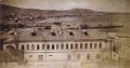 Photograph of Tabe.
 -
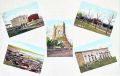 Colorized Postcards of Tabe.
 -
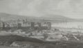 Historical Etching of Tabe.
 -
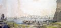 Historical Watercolor of Tabe.


